 |
| View from Queens Garden Trail, near Sunrise Point. |
Shelly's sister Sheryl and her husband Jeff invited us to join them for a short visit to Bryce Canyon. We shared an Airbnb just outside of Panguitch, Utah, a short drive from the Park.
To get to Panguitch is a pretty good drive from our home so we decided to break up the drive by taking Highway 50 and staying in Ely Nevada for one night.
Highway 50 is an interesting drive, (I'd done part of it, getting to Austin via motorcycle a few years back). Turns out that the stretch past Austin is just as interesting, highlighted by Great Basin National Park! We stopped at that park's visitor center to get more information about it. We will definitely return.
We finally made it to Panguitch late in the afternoon and found our rental. It was a cottage on a ranch, with a bedroom and a loft, kitchen and living room. Pretty nice.
 |
| Here's our cottage. |
Sheryl and Jeff arrived later that evening, and we enjoyed grilled chicken and roasted potatoes and a few beers.
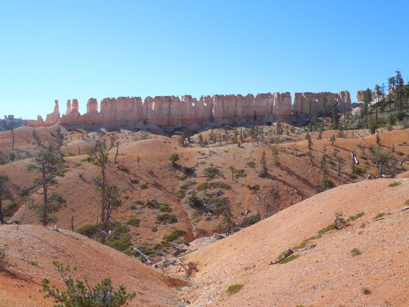
Next morning we set off for Bryce Canyon. On the way you come to some great rock formations and most first timers, us included, stop and photograph these.
 |
| On the way to Bryce Canyon, we're not even at the Park yet! |
Finally, we arrived at the Park. Jeff had a Park Pass which gave us free admission! It took a little hunting to find a parking spot. We were there in mid-September, and there was a fair amount of traffic! During the mid-summer high season, I think I'd take advantage of the Park's shuttle service and park outside.
We stopped at the Visitor's Center at the entrance and picked up a map.
Our first hike would be our most ambitious one, combining the Queens Garden Trail with the Peekaboo Loop Trail. I think we covered almost 8 miles this day, and this is at a fairly high elevation. We all did fine, but you could definitely feel the altitude!
The scenery you witness when hiking through this place is, of course amazing! You can't stop taking pictures, we took over 400!
 |
| Along the Queen's Garden Trail |
We eventually came to the Queen herself, a rock which bears a resemblance to a statue of a seated Queen Victoria:
 |
| Here's the Queen! |
Judge for yourself:
Okay, a little resemblance I guess.
We were close to the bottom of the Canyon at this point and we now joined the Peekaboo Loop Trail, winding our way south to below Bryce Point. Unfortunately, Bryce Point was closed at the time due to bad trail conditions. That's too bad, because it looks like the view from there would be spectacular. Well, there's no shortage of spectacular views around this Park, so no worries!
 |
| A Hoodoo! |
Hoodoo is the name given to the stone spires that are common in Bryce. The shapes start as solid walls, then erosion causes holes which form a window. Finally the window's top wears away leaving the spires.
 |
| This view shows, wall, windows and hoodoos. |
|
|
We followed Peekaboo Loop to Navajo Loop Trail, and at this point headed up to "Wall Street". Wall Street gets its name from the steep switchbacks encountered at the climb to Sunset Point. It's a good little climb and remember, it tops out at 8,000 feet so you feel a little exertion on this one!
 |
| Looking down the "wall", lots of switchbacks! |
At the end of this climb we were at Sunset Point, it was about a half mile hike back to our car. We had a late lunch at Ruby's just outside of the Park Entrance and headed back home to our cottage at Panguitch.
The next day we headed back to the park and hiked a portion of Fairyland Loop Trail, walking to "Tower Bridge". Along the way we had a good view of the "Chinese Wall".
 |
| "Chinese Wall" |
We actually almost missed Tower Bridge, the trail got a little muddled new that point.
 |
| Tower Bridge. |
I'm pretty sure the photo above is Tower Bridge!!
Anyway, we hiked back to our car and decided to drive to Rainbow Point, just about the farthest point south in the Park you can drive to. We had lunch taking in yet another awesome landscape, then headed back north, making several stops along the way.
 |
| Panorama view from Rainbow Pt. |
 |
| Heading back north from Rainbow Pt, we paused at Natural Bridge. |
To reach our final stop of the day we had to exit the Park, then follow Highway 12 to the Mossy Cave trail-head. It was a relatively easy hike to Mossy Cave. Well, it's not much of a cave, but there is a nice waterfall there. The water flows from an old canal system built by Mormon settlers many years ago...
 |
| Along the trail to Mossy Cave. |
 |
| The falls beside Mossy Cave. |
 |
| The Cave itself? Not so impressive! |
It was a nice hike and with that we ended our second day in the Park.
The next day turned out to be one of the highlights of the trip, a visit to the "slot canyon" east of Bryce Canyon. Our directions were a little sketchy but we eventually found the right road...a long stretch of dirt road. We were in our Corolla, so I was a little apprehensive, but the Toyota handled it well, even the little extra but we took when we missed the trail-head!
 |
| At the Slot Canyons! |
The hike was a couple of miles through these canyons. You certainly wouldn't want to be there if there was any chance of rainfall!
 |
| Water trickling through... |
Quite a special hike! We finally turned around and headed back to the car for the ride home...
 |
| ...the view on the drive was wonderful! |
 |
| Along the way. |
On the way back to Panguitch we stopped by the Park for one last side trip; we drove out to Fairyland Point to see the terminus of the Fairyland Loop Trail, (a portion of which we had walked to see Tower Bridge). Then it was back to the ranch for dinner.
The next morning we bid our farewells to Sheryl and Jeff and headed to Salt Lake City, (actually to Ogden), to see Shelly's brother Dale. After a nice visit with Dale and Amy, we headed west on I-80, across the Salt Flats to Nevada.
 |
| 80 MPH in Utah! |
We had booked a room in Wells in the hopes of visiting a small brewery we had discovered at the Reno Blues and Brews Fest. Alas, Ruby Mountain Brewery does not have a tasting room so we were kind of stuck in Wells. We walked around a bit and had dinner at a local diner.
 |
| Wells has a phone booth! |
After an uneventful night we headed west to breakfast in Elko. Thanks to smartphones, we were able to find a pretty nice place. Outside of Elko we stopped at an interesting visitors center that honors the emigrants who past through along the Humboldt River,
californiatrailcenter.org. We were intrigued and wanted to see traces of the wagon wheel ruts which I've heard were around. A lady at the center indicated there were some alongside the Humboldt outside of Carlin. We followed her instructions but, in spite of me even fording the mighty Humboldt, we could find no trace.
 |
| I really tried, here I'm fording the Humboldt! |
Then, on to Winnemucca! We always have to pause in WMC since we spent 5 years there...the town has really grown! We checked out the places we had lived in and drove around town for a while. Then, back on the road.
We stopped in Reno for a bite and a beer at the Brewer's Cabinet then decided to stay the night, booking a room at the Nugget. We managed a little gambling but didn't win big!
Finally got back home that next day. It was a wonderful trip with amazing scenery. There are several other parks and monuments in that part of the country, so we will doubtless be back before long!
Click here for a link to more photos.


Beautiful scenery. The slot canyons look cool.
ReplyDeleteThey are! You live a lot closer, check them out!
ReplyDelete